History on a Postcard
Postcards are associated with tourism and places visited. However, they can also be used for propaganda purposes. Many postcards printed and published between the end of the nineteenth century and 1945 in Germany were used to support German nationalism. This is a (very) short history of Germany during a turbulent time illustrated by postcards of the day.
Prior to 1870 Germany was less a unified country than a loose alliance of principalities loyal to the Habsburg monarchy, with Prussia the largest and strongest. During the mid-nineteenth century, these states attempted to join, convening a general assembly (Nationalversammlung) in Frankfurt. However, provincial rivalries and pressure from Austria and Prussia defeated unification efforts, and the Nationalversammlung disbanded in 1849.
Two rival options for a united Germany had emerged — a "Little Germany" that would exclude Austria from an alliance of states under Prussian control, and a "Greater Germany," with states under Austrian rule. In 1862 Otto von Bismarck became chief minister of Prussia and began to seek reconciliation (and covertly a way to increase the power of Prussia). With Austria's military support, Prussia invaded the duchies of Schleswig, Holstein, and Lauenburg, which then were under Danish control, and gave Austria administration over Holstein. In 1866, after securing French and Italian neutrality, Bismarck sent Prussian forces back into Holstein, on the pretext of poor Austrian administration. In the ensuing war with Austria, Bismarck successfully forced the Habsburgs out of Germany and annexed Schleswig-Holstein, as well as Hanover, Hesse, and the free city of Frankfurt-am-Main.
The unified northern German states signed a military pact of mutual protection with the independent southern German states. Bismarck then succeeded in convincing the northern and southern states to combine forces against the French. Wilhelm I was proclaimed German Emperor at Versailles in 1871, establishing a German Empire under Prussian rule. Figs. 1 and 2 show Germany circa 1900.
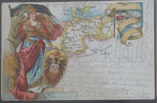
1. Germania and the marine flag border this map of Germany – from Köln to Königsberg and Kiel to Munich – and surrounding countries

The Era of the Empire
An early postcard that has a map of Germany on it depicts a soldier undergoing a medical exam before enlistment. It is designed as a telegram, probably for anxious parents, and printed with the message, "I have passed my medical." The card shows a young recruit standing in front of a wall map. On close examination this map reveals three colored areas within the boundaries of Germany, very probably Oldenburg, Mecklenburg-Schwerin, and Mecklenburg-Strelitz. Although most likely printed during the last years of the nineteenth century, the card appears to represent Germany subsequent to 1871 (Fig 3) but probably dates to late 1890.

3. An early card depicts the obligatory medical exam endured by German recruits: Tief atmen or take a deep breath.
The earliest German postcards were printed about this time, but they did not immediately become successful. Between 1885 and 1895 postcards showing town views, panoramas, soldier recruitment, mountains with faces in them, and special events became increasingly popular for tourists. By the turn of the century postcards were established firmly as a form of correspondence and began portraying more diverse subjects (Fig 4).

4. Tourist card from Lake Constance (Bodensee): if you look closely you can see a nymph swimming!
Two historic cards from the pre-World War I era probably were sold to tourists in the towns in which the events occurred. One depicts military movements during the German war with Denmark, particularly the battle at Duppel Sound, which took place on 18 April 1864 (Fig 5). This card was probably printed at the beginning of the twentieth century. Another card, depicting the Battle of Metz, which took place in August 1870, bears a 1908 postmark from Metz (Fig 6).

5. A map of Alsen Sound on the eastern coast of Denmark site of the Battle of Düppeler Sound of 1864. It shows troop placements during a major battle in Prussia´s war against Denmark under the duchies of Schleswig, Holstein and Lauenburg.

6. Card commemorating the 1870 Battle of Metz, previously a free town within the Holy Roman Empire and later part of France. Germany held it from 1871 to 918; Postmarked 22 June 1908.
Cartographic representations were not common on cards of the time but some did include maps of the German empire, bordered by the typical scenery or products of various regions. Early maps of late-nineteenth-century Germany carry the all-encompassing inscription "Deutsches Reich," but individual principalities sometimes were colored separately. Strasbourg and Metz, though in German hands since 1870, sometimes were shown as part of France.
As with printed maps, it is often difficult to date a postcard's publication with accuracy, as evidenced by the Duppel, Metz, and Deutches Reich maps. Though these all seem to depict events that transpired between 1864 and 1870, they were probably the result of emerging German patriotism in the early twentieth century. The card which shows the figure of Germania (similar to Britannia or Uncle Sam), along with the new flag and the unbroken Baltic coast as far as Konigsberg in the east, correctly shows Strasbourg and Metz as part of Germany. Others depict the newly defined French border, with French and German police officers posing together at crossing points.
The Rise of German Nationalism
German nationalism and expansionist policies contributed to the outbreak of World War I in 1914. Cards survive from this time showing various alliances in caricature fashion, a common feature of such maps in times of crisis. One of a popular series shows the various countries as little, soldier-like figures, with Germany and Austria fighting the rest of the world, Japan attacking Russia from behind, and England pulling a ship onto shore, representing Britain's sea power (and possibly its demand that Germany not produce large battleships). Another series had the countries' outlines transformed into characters: Russia, with Poland as its nose (e.g., "I have really poked my nose into something"); England looking poorly; and a combined Germany, Austria, and Hungary, e.g. "Unity is strength", Fig 7.

7. An example of a map of Europe in caricature. The Austro-Hungarian-German alliance in red.
Perhaps the most famous motif from this era shows the two emperors, Wilhelm II and Franz-Joseph I, above a map of their two countries, with a German soldier and an Austrian soldier shaking hands below (Fig 8).

8. Portraits of Kaiser Wilhelm II of Germany and Kaiser Franz-Josef I of Austria oversee the symbolic alliance of their empires. Eastern Germany is pink with Poland green and Austria yellow. 1914-1915.
Several postcard maps depict the various theaters of war in Europe, including the sea blockade of Great Britain. Three series of maps — Western Theater of War, Eastern Theater of War, and Paris and its Fortifications— were produced at various scales. Some cards celebrate particular battles; the 1916 Siege of Verdun, for example, is illustrated in cards showing the lines of defense (Fig 9). Some soldiers used the cards to indicate to relatives where they were stationed. Later cards showed German submarine successes (Fig 10).

9. Card of area around Thiacourt to the west of the Mosel River: note markings added by soldier.

10. A map of the Mediterranean shows the success of German submarines. The statistics (right) give a month-by-month tonnage sunk between February 1917 and January 1918. Postmarked 11 October 1918.
The Weimar Republic
Anger at the terms of the Treaty of Versailles led to a consolidation of German nationalism, as can be seen in many postcards during the period of the Weimar Republic. An interesting piece of postcard propaganda depicts a map that supposedly appeared in a French publication. Germans published it as a postcard with the text: "This is how our enemies want to divide Germany." The map depicts a much-reduced Germany, composed mainly of the Land of Thuringia, with surrounding areas occupied by foreign powers. England occupies the area surrounding Oldenburg, Munster, and Elberfeld, regions later occupied by the British after World War II (Fig 11).

11. Thuringe will be all that is left of Germany once the other countries have “invaded” its borders – warning of what will come. It is almost more graphic in black and white.
The outrage Germans felt at the carving up of their country also is captured in cards depicting the Polish Corridor, which altered the relationship between eastern Prussia, Poland, and Danzig (Gdansk, a port on the Baltic coast). The Treaty of Versailles defined the border as falling along the middle of the Vistula (Weichsel) River (Fig 12).

12. Map of the Free State of Danzig (Freie Stadt) and area to south, including Der Korridor and Ostpr- Text in box below map is very patriotic. The five separated villages are discussed in the text.
However, the border actually was established to the east of the river, at one point annexing to Poland five villages with mainly German-speaking populations. These villages (Fünf Weichseldörfer) are shown in postcards of the period, one of which describes them as "cut off from the Reich and delivered over to Poland's capriciousness/despotism." A later state of this postcard shows an area a few miles to the east and issues less inflammatory text ("cut off due to redrawing of the borders").
Another card depicting the border has black-and-white shading — only Poland and Lithuania are white — suggesting that Germans composed the majority in the gray areas, which actually was not the case. Suggestive mapping was very strong during the years of the Weimar Republic following the First World War (Fig 13).

13. Map of eastern part of the Deutches Reich (east of Berlin), Polish corridor and Ost-Preussen (eastern Prussia).
Nazi Propaganda Cards
In 1935 the people of the historically contended Saar region in southwestern Germany, which had been awarded to France after World War I, held a plebiscite in which they voted to return to German rule (Fig 14). A card produced that year sports a swastika and symbols of National Socialism, and the title "Back to the Fatherland: Referendum."

14. Map of Saarland. The area known as Der Gau is highlighted as French territory. Published as a folding card with patriotic text.
Adolf Hitler's troops marched into Austria in 1938. Soon after, postcards appeared showing Hitler's head superimposed on a map of the redefined Germany with the ubiquitous statement, "One people, one empire, one leader," and the German - eagle and swastika adorning the whole. Another popular slogan of the time declared, "Austria comes home!"
Other postcards of the era connect German-speaking peoples in other countries. One simple card from 1938 depicts Germany and Austria in bright red, with German-speaking areas within Czech territory shown in hatched color. The familiar nationalistic text and eagle are superimposed. On 29 September 1938 Germany invaded German-speaking areas of the Sudetenland (in Bohemia). Subsequent postcards show a map of western Czechoslovakia, with occupied towns and cities, and Hitler being greeted in the central part by a large crowd. It is unclear whether these crowds represent Sudeten Germans welcoming liberation or a portent of the fall of Czechoslovakia in 1939. The card, some copies of which bear Hitler's signature, is one among a large number of coltish postcards depicting Hitler in various affectations (Fig 15).

15. We Thank Our Führer: Stylized map of mainly Czech area with a portrait of Adolf Hitler surrounded by a cheering crowd. Printed stamp dated 4 December 1938 (after occupation of Bohemia, Moravia and Silesia).
Propaganda cards appeared in other European countries as well. A 1939 French postcard of a cartoon by Paul Barbier shows a nightmarish vision of "Hitler's Dream." He sits on a chair with hands tensed, behind and above are a bleeding Earth and Moon, covered with the word Deutschland (Fig 16).

16. Hitler´s Dream: Hitler sits with a bleeding globe and moon all marked Deutschland (French: There is also an English variant).
The production of map postcards declined during the war. The National Socialists produced relatively few accurate maps but many symbolic or propaganda maps on postcards. However, some successes were celebrated with postcards, such as the Durchbruch (breakthrough) of tank divisions in 1940, in which the routes from Belgium to northern France, Antwerp, and Ostend were immortalized. After a successful push by the Tenth Armored Division, a card was issued depicting its three-month, 3,020-kilometer march from Bernkastel to Paris via Calais, Lyon and Cognac. Proceeds from the sale of the card went to a memorial for the division's fallen (Fig 17).

17. The Tenth Armored Division marched from Bernkastel to Paris via Calais, Lyon and Cognac. Proceeds from the sale of the card went to a memorial for the division's fallen.
We traditionally think of postcards as the stationery of tourists. For Germans of a certain period, at least, they also served a larger and more serious purpose. They expressed nationalist aspirations and encouraged national unity. The picture of German history depicted in these cards may strike some as superficial and even propagandistic, but few can ignore the passions, prejudices, and political dreams they represent.
This article first appeared in Mercator´s World March/April 1998, Volume 3 Number 2.
Further Reading
Herb, Guntrum Henrik. Under the Map of Germany: Nationalism and Propaganda, 1918-1945. London and New York: Routledge, 1997.
Taylor, A.J.P. The First World War. London: Penguin, 1966.
Gilmartin, Patricia. "Terrae Animatae: Metamorphic Maps on Postcards." The Map Collector 68 (Autumn 1994): 2-8.
Monmonier, Mark. How to Lie with Maps. Chicago and London: University of Chicago Press, 1991,1996.

No comments:
Post a Comment